

State of emergency Sunrise, Burdette Fires rage as governor declares fire emergency

The Rogers Mountain-Lazier Creek 3 Fires, which started on July 8 in Sanders County, have all been 100 percent contained. (Erin Jusseaume/Clark Fork Valley Press)

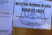
Travelers at Fish Creek were greeted by signs warning about the Burdette Fire burning south of the creek. As of Sunday, the fire had grown to 440 acres, with threats of it spreading into Petty Creek. (Kathleen Woodford/Mineral Independent)

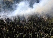
The Burdette Fire started on July 16 by lightning and is burning in remote mountain terrain. (Photo courtesy of the Lolo National Forest)

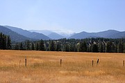
The Sunrise Fire burning 12 miles east of Superior has grown to 1,000 acres and threatens approximately 50 homes in the Quartz Creek area. (Kathleen Woodford/Mineral Independent)
Gov. Steve Bullock declared a fire emergency for the state of Montana on July 23. The order cites several active wildfires in the state, “Montana is facing extreme fire conditions,” he states. “Our top priority is ensuring the safety of Montanans, their property, and our communities.”
The declaration permits Bullock to move additional state resources and the Montana National Guard to fight fires. Where high pressure and dry conditions continued to press across the state with a red flag warning in place with very hot, dry and winds expected Monday afternoon and evening.
Meanwhile, Mineral County residents were casting a wary eye toward two fires raging in the mountains south of the Clark Fork River — the Burdette Fire located 13 miles southeast of Tarkio and two miles east of the South Fork Fish Creek drainage on the Ninemile Ranger District; and the Sunrise Fire approximately 12 miles east of Superior.
As of the afternoon of July 23, the Burdette Fire was at 440 acres with 34 personnel on the scene. This lightning-caused blaze started on July 16 at midnight. There is concern about fire getting into Petty Creek where there are a number of homes and private property. Fire-containment strategy continues for the area including Wig Creek, with hopes for containment by Aug 1.
Also Sunday afternoon, the Sunrise Fire had grown to 1,000 acres, where 300 personnel including seven hand crews, three helicopters and three dozers were battling the blaze. The Sunrise Point Road No. 7789 is closed, with fires burning at Meadow Creek. Homes along Quartz Creek are threatened and a base camp has been established at Tarkio. Crews hope to have the fire contained by Aug. 1.
About 65 residents attended an informational meeting held at the Lozeau Lodge on Saturday evening. Nearly 50 area homes were threatened by the fires.
Several emergency personnel were on hand to inform locals about the fires and possible evacuation plans. Attending were Erin Phelps with the Nine Miles Ranger District, Sheriff Tom Bauer, and Shawn Pearson. Pearson’s Northern Rockies Type 2 Incident Management Team assumed command of the fires on July 22.
Other area fires include the Lolo Peak Fire raging between the Meadow Creek and Falls Creek drainages of the South Fork of Lolo Creek. On Monday reports said the majority of the 750-acre fire is burning within the northern boundary of the Selway-Bitterroot Wilderness. It was lightning-caused and had 106 personnel assigned to fight the blaze.
Other fires burning in the Lolo National Forest include the 1,817 acre Goat Creek Fire which was 0 percent contained as of Monday. The Sliderock Fire at 396 acres was 5 percent contained and the Little Hogback Fire is burning at 2,326 acres with 0 percent containment. The 410-acre Monahan Fire in the Bob Marshal Wilderness area also is burning. As of press time on Monday, the Lolo National Forest issued a Red Flag Warning in effect between 2 and 9 p.m. for critical fire weather with shifting winds out of the northwest.
In Sanders County, the Rogers Mountain-Lazier Creek 3 Fires, which started on July 8, have been fully contained. The Lazier Creek Fire burned 1,145 acres, which was located south of U.S. 2 and west of the Thompson River Road.
The Rogers Mountain Fire burned 78 acres, located 3 miles northwest of Happy’s Inn; the Grubb Fire burned 16 acres north of Pleasant Valley, the Northwest Meadow Peak Fire burned 12 acres and the 2645 Fire burned 4 acres. All are completely extinguished.
In the Lewis and Clark National Forest near Helena, several other fires are being reported, including the 75-acre Limburger Fire and the 2,500-acre Arrastra Creek Fire. The Park Creek Fire has burned 2,900 acres and the Lookout Fire near Wolf Creek had burned 390 acres by July 22.
The Beaverhead/Deerlodge National Forest is reporting the Meyers Fire burning at 895 acres, the Whetstone Ridge Fire currently at 1,504 acres.
Other fire activity in the state includes the Yooper fire burning near Miles City, which was at 7,817 acres as of July 23 and 30 percent contained. The Chinn Fire near While Sulphur Springs expanded to 3,300 acres and was 15 percent contained.
The Crying Fire near Benzien grew to 7,925 acres and was 30 percent contained. The Lodgepole Complex near Jordan was at 200,000 acres with 0 percent containment.