

Team assesses damage from Highway 200 Complex


The 2017 wildfire season is in the books, however now is the time for some Forest Service workers to assess the damage that was done.
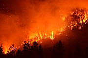
The Burned Area Emergency Response team, known as B.A.E.R., is assessing the Highway 200 Complex fires, such as the large Sheep Gap Fire that ran close to Plains.
District ranger David Hattis of the Forest Service said that this type of risk assessment team is necessary.
“It’s not just the trees and the area burned by the fires; it is the culverts, the roads, the soil. B.A.E.R. looks at it all and they are experts in managing risk assessments so we know just ‘how bad’ the fires really were,” said Hattis.
The purpose of the B.A.E.R. program is to identify threats to human life and safety, forest infrastructure and critical natural and cultural resources.
Following identification of risks posed to critical values, treatments are prescribed to mitigate those identified risks.
B.A.E.R. is specific to federal lands; other programs work to address threats and risks to resource values on lands of other ownerships.
James (Andy) Efta, B.A.E.R. team leader that came to Sanders County to conduct the assessments, explained some of the recommendations made for the area.
“The Highway 200 Complex and Moose Peak B.A.E.R. team consisted of engineers, soil scientists, hydrologists, a fish biologist, botanists, recreation specialists, and a GIS specialist,” said Efta.
“The team first set out to understand burn pattern and watershed effects associated with the wildfire. Out of this process, burn severity maps were produced for each fire showing areas of high, moderate and low burn severity. Next, critical resource values were assessed using the burn severity data and risk to those values was determined,” he further explained.
“Those values where unacceptable risks were identified were recommended for treatment. The team’s recommendations came in the form of specialist reports and a master assessment report and funding request,” continued Efta. “Following the Lolo and Kootenai National Forests’ review and approval, those documents are then reviewed by the Forest Service’s regional office in Missoula and in some cases by Washington Office personnel.”
Efta went on to explain that there were a variety of recommendations for the area he and his team assessed in Sanders County.
Recommendations ranged from road drainage improvements and stream crossing upgrades, to weed detection and treatment to cultural site management. He said that the areas recommended for treatment generally burned under moderate to high severities.
Efta explained that funding for these improvements would come through earmarks in the Forest Service’s annual suppression budget.
“B.A.E.R. is about mitigating risk to critical values. The intent is to protect human health and safety, taxpayer investments in infrastructure, and to work to manage unacceptable losses to natural resources. Through our collaboration with the affected ranger districts, NRCS, the Weather Service, we’ve doing our best to communicate our findings and the benefits to forest users,” said Efta of the importance of having the specialized team come to the area.
“B.A.E.R. treatments are not intended to mitigate risk of wildfire. Through implementation of recommended treatments, however, those values identified under B.A.E.R. are more likely to avoid being compromised in the next few years as the forest recovers from the fire,” he added.
Efta said that treatment implementation is slate to begin within the next few weeks on several of the wildfires within the Highway 200 complex area.