

Flooding threat Clark Fork reaches highest level in 100 years

Fish Creek Road washed out at mile marker 12 on Thursday, May 10, and people were being redirected to Petty Creek. (Photo courtesy of Lolo National Forest)

A pair of geese float along the Clark Fork River which may crest 17 feet in some areas by the end of the week. (Kathleen Woodford/Mineral Independent).

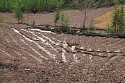
Flat Creek which is a Superfund site for the old Iron Mountain Mine, flooded, reseeding efforts were damaged and the creek carved a new channel. Crews will revisit the area for repairs after waters levels decrease. (Kathleen Woodford/Mineral Independent).

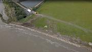
The Plains Waste Water Treatment Lagoon was threatened by Clark Fork flood waters and the U.S. Army Corps of Engineers stepped in and helped secure the eroding river banks. (Photo courtesy of Plains-Paradise Rural Fire Department)

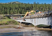
Crews remove a large tree anchored onto the Petty Creek bridge last weekend near Alberton for fear other debris would build up around it. (Photo by Jay Styles)

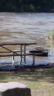
The Forest Grove Camp Ground near Superior was flooded, along with several other fishing access sites as river waters continue to rise (Photo by Lori Dove)
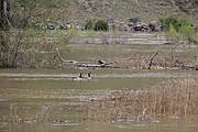
The Clark Fork River in Plains reached 16.26 feet feet over the weekend. Officials say this is the highest the Clark Fork has been in 100 years.
With flows up to 51,100 cubic feet per second, it has left residents and emergency crews scrambling to stay in front of areas flooded by the muddy waters, including those in Plains and Missoula.
Minor flooding occurs at 16 feet, and over the coming week, the river is forecast to reach as much as 17.71 feet, which is close to the range of moderate flooding risk.
A cooling trend over the weekend did allow rivers to recede; however, temperatures are forecast to rise this week and melting snowpack will accelerate, which will lead to the likelihood of water levels rising again.
Over the last week, little flood damage was reported in Mineral County, though residents in the Two-River and Peninsula subdivisions near St. Regis have been sandbagging as rising water threatens homes, said Mineral County Disaster and Emergency Services Coordinator, Lori Dove.
Sand was made available at the Superior County Shop and the St. Regis Volunteer Fire Department thanks to Denley Loge. Sandbags are available at the Superior and St. Regis Fire Departments as well as at the Frenchtown Rural Fire Department. The road into Fish Creek, near mile marker 12 had flooded by Thursday, May 10 and people were being redirected to Petty Creek. Also, the Forest Grove Fishing Access off of Mullen Road East was flooded.
In the surrounding area, the Plains Waste Water Treatment Lagoon was threatened by Clark Fork flood waters and the US Army Corps of Engineers moved quickly to sandbag eroding river banks. Another area of concern is the unmaintained earthen berm at the former Smurfit-Stone mill site in Frenchtown. The mill closed in 2010 and there are settling ponds containing toxic material. If the berms fail, toxins will be released into the river.
In Missoula, several neighborhoods flooded and mandatory evacuation orders and warnings were put into place late last week for up to 800 homes. Areas included the Orchard Homes neighborhood, and those north of Third Street. Residents are warned not to go near the rivers because of the strong currents and debris. Missoula officials were also concerned about homes and other large items washing downstream, possibly hitting, and taking out bridges. Including three unoccupied trailer homes and a large propane tank that were shaken from their foundations and washed down stream.
Several fishing access sites were closed by Fish, Wildlife, and Parks including Schwartz Creek, Turah, Kelly Island, Kona Bridge, and Harpers Bridge in Region 1. The flooding also caused minor damage to Flat Creek which is a Superfund site located north of Superior. Areas were reseeded after contaminants from the old Iron Mountain Mine and Mill had been removed and flooding has washed some of those areas out.
Joel Chavez, the site manager, said all contaminants have been removed and nothing but muddy water is washing into the Clark Fork River at this time. Crews are keeping an eye on the water levels and once they go down, repair work will begin.
Money was set aside just in case issues like this happen, Chavez said. “It’s something we hope doesn’t happen but springtime can bring flooding and so we prepare for it and have the funds to fix it.”
He said the water has carved out a new channel that they will need to fix but no infrastructure like roads or culverts has been damaged.