Friday, April 26, 2024
43.0°F

State fish biologist discusses Clark Fork River pollution
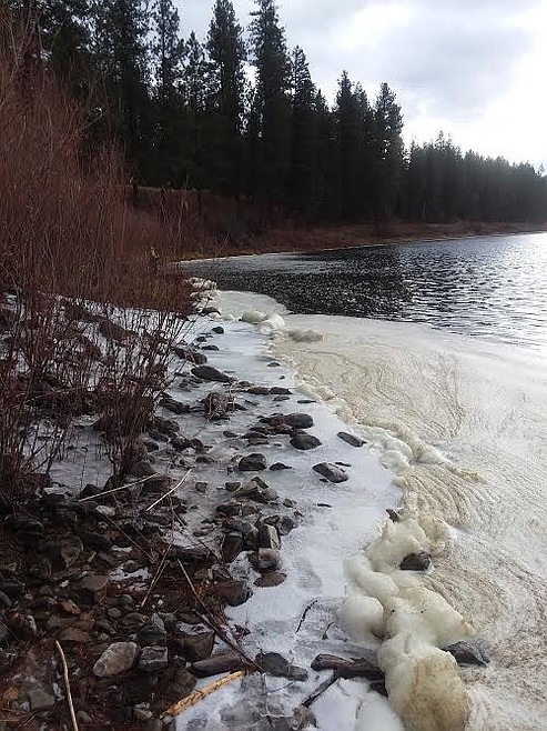
by MONTE TURNER
Mineral Independent | December 30, 2020 12:00 AM

The Clark Fork River has long sweeps through both Mineral and Sanders counties where it touches its residents in one way or another.

Fishing, floating, swimming, hunting, bird watching, photography, if locals aren't using it directly for recreation, other people from out of state do and they spend money with our local merchants that fuels the economic base.

But a recent discovery is jarring as most everyone felt the river was becoming healthier through environmental organizations and Environmental Protection Agency guidelines and standards.

A visit with Ladd Knotek, Fisheries Management Biologist for Montana Fish Wildlife & Parks Region 2 has helped explain when and where it became jeopardized and where we are today.

1. What are the toxins in the Clark Fork and where did they originate?

The Clark Fork has a long history of contamination that mirrors the industries and geology along its route. Historically, hard rock mining in the headwaters (e.g., Butte-Anaconda area) lead to heavy metal contamination in the river including copper, zinc, arsenic, lead, and cadmium.

The Flint Creek drainage is also a major source for mercury for the Clark Fork River.

However, the most recent sampling was conducted to test for specific contaminants that are often associated with the pulp and paper production industry, including dioxins, furans, and PCBs.

Northern pike and rainbow trout were collected in 2013, and then again in 2018 and 2019 from the Clark Fork River upstream and downstream of the former Smurfit-Stone Container mill site, the Blackfoot River, and from the Bitterroot River.

The mill may be a source of these contaminants, but there are other potential sources for the middle/lower Clark Fork River including the Bonner Mill, and even a site in the Bitterroot River upstream of Florence.

The removal of millions of cubic yards of sediments laden with contaminants from the former Milltown Dam reservoir, as well as continued remediation of stream banks and floodplain in the upper Clark Fork River Basin, have started to improve water quality in the Clark Fork that was degraded by heavy metals. However, these contaminants are different substances and originate from different sources than dioxins, furans, and PCBs found in fish predominantly below the Bitterroot River.

Future sampling will hopefully reveal the range and relative magnitude of sources for the various contaminants, as well as identify options for clean-up.

2. Up until recently, it was advised that a person shouldn’t eat more than a couple of meals a week of fish caught in the Clark Fork River. Now we’ve been advised not to eat any. What has changed?

In 2013, FWP sampled a limited number of northern pike and rainbow trout (from the Frenchtown area only) for dioxins and furans. Based on the results of that sampling, fish consumption guidance/guidelines were issued, which recommended avoiding consumption of all northern pike, and four meals per month of rainbow trout. Due to the uncertain geographic extent of contamination, a larger reach of the Clark Fork River from the Bitterroot River mouth to the Flathead River mouth was included in the fish consumption guidelines issued at that time.

New sampling in 2018 and 2019 confirmed high contaminant levels in northern pike and found higher concentrations of contaminants in rainbow trout that warranted them a being added to the ‘avoid consumption’ list. The reason why the concentrations were higher in recent sampling were likely due to leaving the skin on for analysis (recommended for dioxins) and we also analyzed for co-planer PCBs, which are added together with the dioxins and furans. Other species of fish in the Clark Fork from the Bitterroot River to the Flathead River are included in the advisory because they have similar food habits, habit use, and life-span as northern pike and rainbow trout and suggests they would likely contain possible concentrations at potentially dangerous levels.

3. Is this the entire Clark Fork or what portion is affected?

The current advisory on the Clark Fork River extends from the Bitterroot River confluence to the Flathead River confluence. Sampling was also conducted upstream of Missoula in the Blackfoot, Bitterroot and Clark Fork rivers. There is some restricted guidance for these sections but only the largest northern pike from the Bitterroot River have an advisory to "avoid" consumption.

The sites at Turah and Greenough on the Blackfoot show lower levels of contaminants and, as a result, do not warrant the same restrictions recommended for downstream of the Bitterroot confluence on the Clark Fork River.

4. What are you aware of that is being done to improve the water condition?

The EPA is currently working through the Superfund process to assess impacts from the former Smurfit-Stone Container Mill site on human health and to the environment. The EPA recently released the Human Health and Ecological Risk Assessments, which will be followed by a Remedial Investigation that fills in data gaps at the site and a Feasibility Study where any alternatives would be evaluated. Based on the conclusions the EPA reaches in the risk assessments, and if they determine it is warranted, the EPA may conduct a more thorough investigation.

5. Without going too deep into the weeds, can you explain what this picture displays and why isn’t this foam on the Blackfoot, Bitterroot or Flathead rivers?

Foam on the water’s surface is occasionally observed on various local rivers but is most commonly seen accumulating in eddies on the Clark Fork River. The cause of foam concentrations is somewhat speculative, but it is believed to result from elevated phosphate levels and airborne dust. Some of the phosphorus in the Clark Fork River is naturally occurring (it is a very productive river and we even have a town named for it - Phosphate), but humans, development, etc. no doubt supplement background phosphorus levels.

6. On rainbows and cutthroats, do you have information on fish-per-mile on the Clark Fork?

Fish population estimates have been conducted routinely on rivers throughout the region for decades. Established trout population estimate sections (for all trout more than 8 inches in length) occur in several reaches of the middle Clark Fork between Rock Creek and the Flathead River confluence. These include sections near Turah, Milltown, Huson, Superior and St. Regis.

Population estimates in these sections are surprisingly similar and consistent. Estimates tend to range from 200 to 500 catchable trout per mile. Fish densities have generally oscillated within this range over the past few decades. Important factors affecting the trout densities over time and among sites include flow levels and summer max temperatures (associated with drought), number of functioning tributaries within the reach (that serve as spawning and nursery areas for our wild trout populations), and quality of tributary habitats.

The trout species composition varies somewhat among river reaches, but tends to be 75%-95% rainbow trout, westslope cutthroat grout, and hybrids of these two species. Native (unhybridized) westslope cutthroat trout typically comprise 5% -15% of the trout population in various reaches of the Clark Fork River. Just as an example, the Superior population monitoring section tends to be one of the more consistent and higher density Clark Fork River sections for trout, presumably because Trout, Cedar and Dry creeks as well as other tributary streams all enter the river in this area and supply consistent offspring (recruitment).

7. What do you recommend to northern pike anglers for catching and eating? Is this a good time to be fishing for them?

Updated consumption advisories for the middle Clark Fork River recommend that people don’t eat northern pike or any fish species from that reach. Anglers should keep in mind that consumption advisories are conservative and take consumption of fish over a person’s lifetime into account, but based on the contaminant types and levels the state of Montana does not recommend that anglers eat northern pike and other species caught in the Clark Fork River between the Bitterroot River confluence and the Flathead River confluence.

Regarding northern pike angling in general on area rivers, catch rates have traditionally been highest in spring. This period coincides with spawning when fish are concentrated in shallower backwaters. It also coincides with warming water temperatures, rising water levels (that flood backwaters) and higher turbidity - which can offer a good ‘window of opportunity.’ That said, anglers are consistently catching pike spring through fall. Like most fishing, angler success is largely based on understanding fish behavior, movements, and habitat/food preferences when you go.. they’re usually biting somewhere.

As with all game fish, recommendations for eating include:

  • Do a good job cleaning – remove skin, fatty tissue and entrails from fillets;
  • Focus harvest on smaller/medium sized fish as meat quality is typically higher and potential bio-accumulating contaminants are assumed lower in younger fish;
  • Keep fish to eat when water temperatures are cooler and keep harvested fish/fillets on ice – as flesh tends to be firmer and maintains higher quality when kept cold.

8. What is important for people to know about the fish in the Clark Fork River?

People often ask what the biggest threats are for our local trout fisheries. The most obvious threats/concerns are pollution, warming water temperature (the Clark Fork in particular is already on the edge of suitability for cold water fish species like trout) and continued introduction and expansion of warmwater/cool water fish like northern pike, smallmouth bass, walleye, yellow perch, sunfish, etc.

Our local rivers support unique, world renowned, wild and native trout fisheries that are currently valued at more than $100 million for the local economy in Western Montana (University of Montana and state Department of Tourism Economic Value estimates) and support more than 240,000 angler-days per year (MFWP 2019 Angler Use Estimates). These economic, social and ecological values continue to be threatened by habitat degradation and unauthorized fish introductions.